The Council’s Officers have told us they believe the scheme is compatible with its location in the Staines Conservation Area. When you read this essay you will wonder how they came to this conclusion.
The 14-storey hotel and apartment complex announced by Spelthorne Borough Council and the Arora hotel group in May 2020 is two-and-a-half time taller and several times the mass of any other building anywhere near it. The sensitive riverfront site on which it would be built, next to Staines Bridge, sits at the heart of the Staines Conservation Area
and overlooks the Egham Hythe Conservation Area on the other side of the river.
There is an overwhelming Conservation and Heritage case against a development of anything close to the proposed height and size of the Arora scheme. Nowhere on the Thames outside the major cities of London and Reading is there anything approaching the disfiguring impact on its context as the proposed Arora scheme.
A Conservation Area is defined in the National Planning Policy Framework guidelines as “an area of special architectural or historic interest, the character or appearance of which it is desirable to preserve or enhance.” Staines Conservation Area, officially designated in 1975, covers the riverside and central Staines.
The proposed Arora development would dominate the entire area, overwhelm its heritage assets, and wreck its character and appearance. In doing so it would make a mockery of the NPPF guidelines on Conservation Areas.
In fact Spelthorne Borough Council has itself made a strong case in the past against any development on this site approaching the height and mass of the Arora scheme. In its Planning Brief for an earlier proposed development of this site, the Council insisted “the mass of the building will need to be such that it fits in with the pattern and scale of buildings in the locality and, in particular, care must be taken not to harm the setting of the nearby listed buildings … the height should not exceed the height of adjoining buildings and not result in the properties on the north side of Clarence Street being over dominated … The development should not obscure the important view from Staines Bridge of the historic St Mary’s Church in Church Street.”
The features of the Staines Conservation Area which have earned it the official designation are many and various. They include the important history of the area, the many historic buildings and structures and the view of and from its riverside. Here’s a selection of them.
History
There’s been human settlement in the area since Roman times at least, this being the point at which the Roman road from London to Bath crossed the Thames. It provided the only bridge across the river above London Bridge until around 1400. The rivers Thames and Colne were for centuries important commercial transport (Roman wharfs, etc) and power sources, pleasure and leisure use taking over in the last 150 years.
As the settlement grew around the river crossing the commercial importance of Staines and the ‘hythe’ (port) on the other side of the river increased. Coaching inns, a brewery and the linoleum factory all appeared there bringing in the residences appropriate to a substantial market town.
Staines Bridge
Designed by John Rennie (who was also responsible for London Bridge) it was completed in 1832 to replace earlier bridges which had spanned the river behind the Town Hall site.
Aside from its historical significance the Bridge is important for its classical design and as a grand entrance to the town from which much else can be seen, including the church, the brewery tower, the town hall and the Clarence St terrace.
The Arora scheme would hide the church and brewery tower from view and present a very unbalanced approach to the town from the bridge.
St Mary’s stands on a site of older churches, the first recorded in 675AD. The present building was built in 1828 although parts of the tower are older. On an elevated position it could be seen from most of the surrounding area. It is a statutorily listed (Grade II*) building and the view of it from Staines Bridge is protected.
Views of and from church would be completely obliterated by the Arora scheme.
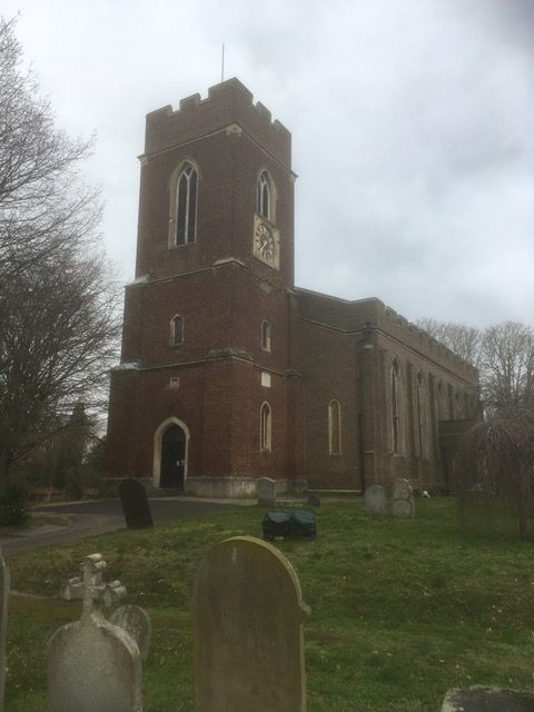
St Mary’s Church
The Ashby family, who established themselves in Staines around 1750, started a brewery business in the kitchen of the family house at 57 Church Street (a listed building dating from 1737). The business expanded and several other buildings were built close by to accommodate it, including the Brewery Tower in Church Street and the Malthouse in Wraysbury Road. Both of these are listed buildings and the view of the Brewery Tower from Staines Bridge is important.
Views of the Brewery Tower from the bridge would be completely blocked by the Arora scheme.
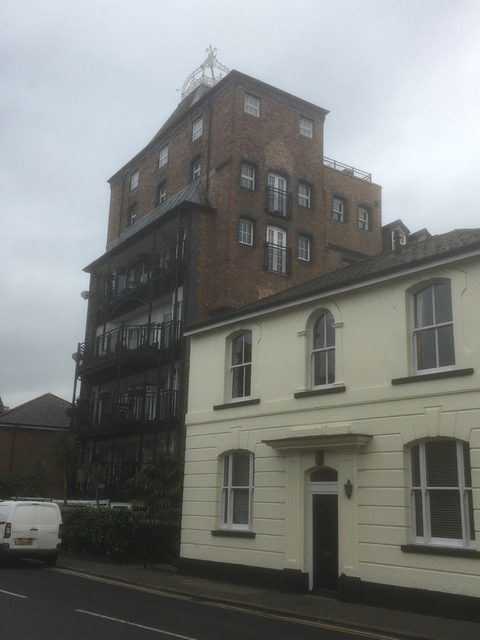
The Brewery Tower and related buildings
Many houses on the north side of Church Street are listed buildings with dates ranging from the 17th to early 19th centuries. This, accompanied by many later buildings of sympathetic design and a road layout from a horse-drawn age, gives the entire street its historic feel, unmatched in the rest of the town.
The Arora scheme would dominate and overshadow Church Street’s sensitive historic streetscape.

Church Street
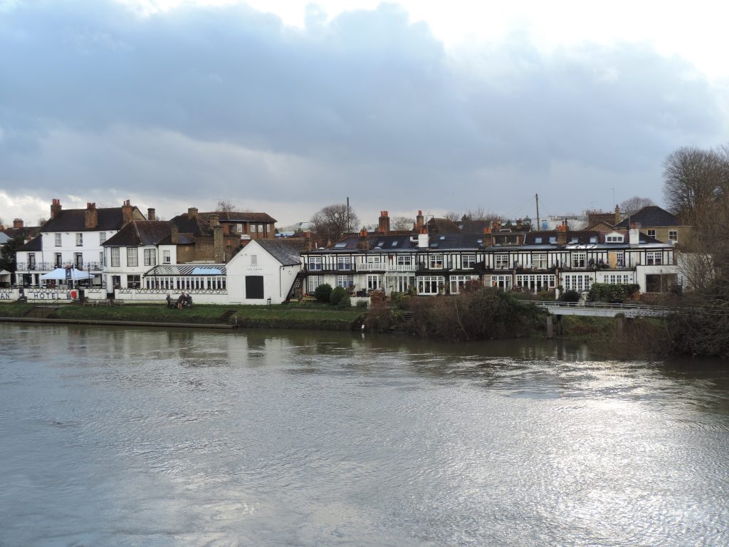
Moving the location of Staines Bridge to its present position required the building of Clarence Street and a bridge over the river Colne. The Regency/Georgian houses between the Colne and Bridge Street were built between 1832 and 1835. They are a key element of the view from the bridge with the corner building, originally the Literary & Scientific Institute, the focal point. All the buildings and the Colne bridge are listed.
The Arora scheme would completely compromise and unbalance views to and from the historic Clarence Street.
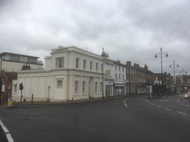
Clarence Street
Originally on the approach to the old bridges, the Market Square had much of very old Staines. The main example is the Blue Anchor Inn built in 1721 and notable for its painted windows bricked up to avoid window tax. More recent is the Town Hall and Fire Station built around 1880 but probably the area’s iconic buildings. All these are listed, the Inn as Grade II*. The Town hall is part of the view from Staines Bridge.
The Arora scheme would be entirely unsympathetic with its historic neighbouring group of buildings.
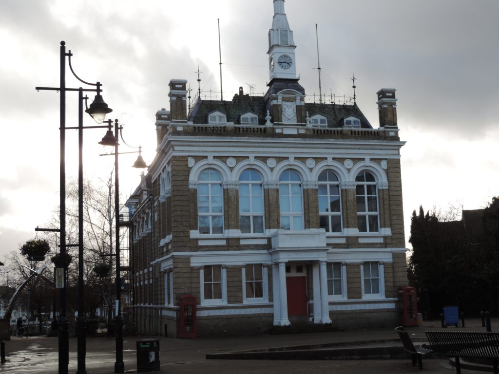
Town Hall and Market Square
Thames riverside
The view of the riverside is hugely important to the appearance of the Conservation Area and to its character. What we currently have is a pleasant footpath/promenade backed by buildings of no more than five storeys. Those viewing the Area from the Egham side of the river can see the Church, the Brewery Tower, the Town Hall and the Clarence St houses, all of which make a statement about the character of the Area and the town beyond it.
The Arora scheme would completely obstruct most of those views and entirely change the character of the area.
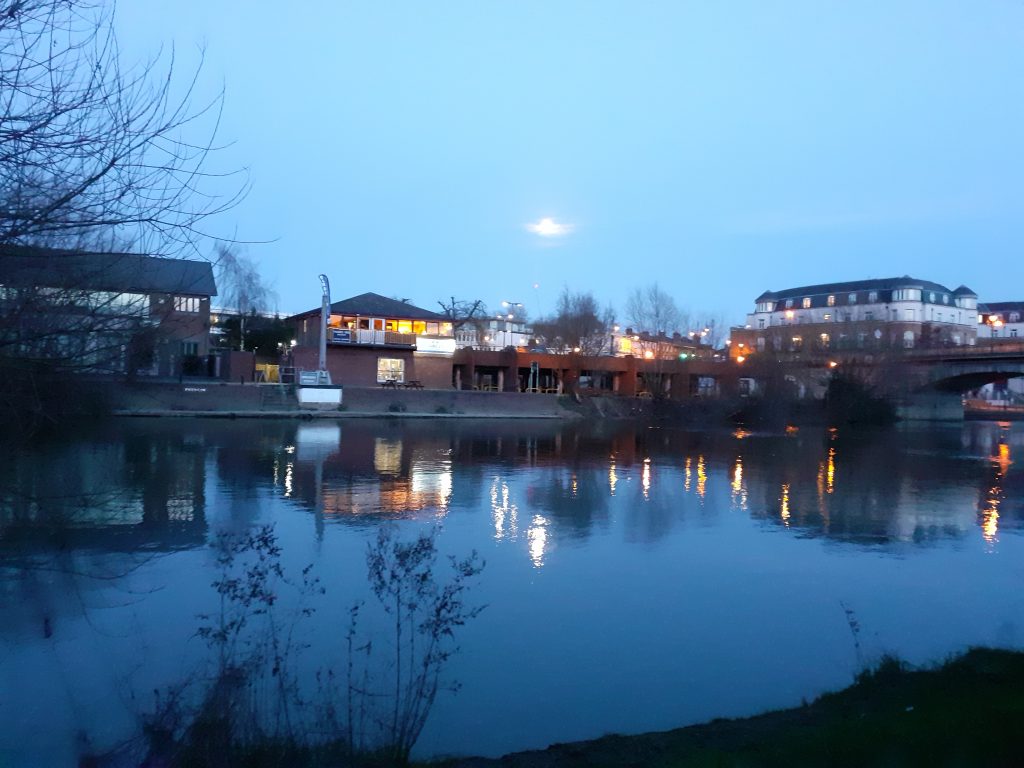
The site as it is today
Egham Hythe Conservation Area
Anything built on the Bridge Street Car Park site will have a significant impact on the Egham Hythe Conservation Area, on the Runnymede side of the river. In fact this Conservation Area and the Staines Conservation Area were one and the same until Spelthorne and Runnymede were split into two separate boroughs. The Egham Hythe Conservation Area has considerable heritage context, with all but two of its riverfront properties Grade II Listed (12 of The Hythe’s 28 Listed properties).
The whole community on the Egham Hythe side of the river would be dramatically and adversely impacted by the Arora scheme.
Egham Hythe Conservation Area
Peter Bower, Riverside Residents (Staines) Coalition. January 2021